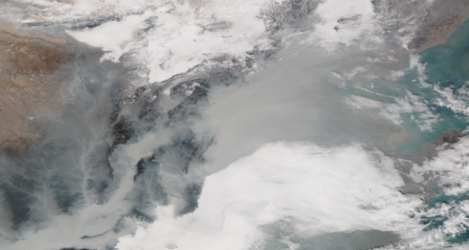
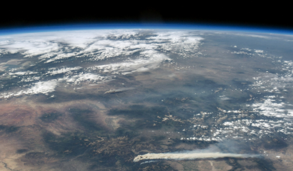
The use of satellite cameras that identify the level of pollution in an urban area is not something new. We use satellite data for air quality when we need to determine when pollution levels in a given area increased to alarming levels. Environmental monitoring helps us take necessary measures against air contamination so that our planet remains healthy, and we can keep a safe home for us as species. Luckily, we have the technology of satellite cameras necessary to ensure our planetary future is stable, and we can survive on Earth.
How are satellites used to detect air quality?
Satellites use cameras that detect long-range pollutants from different regions. However, these cameras can’t show how polluted an atmosphere is at the ground level. Satellite cameras send information about any pollutants present in the atmosphere all around a region, but these pollutants could also penetrate lower atmospheric levels that are not easy to monitor with cameras. Primarily, Earth observation satellites (EOS) cameras measure the atmospheric concentration of aerosols or particles by making observations on how the light gets to the Earth’s surface and how many light aerosols reflect. This is called aerosol optical thickness or aerosol optical depth. Such measurements are like the ones made with a photometer at the ground.
Another method of detecting air quality with the help of space cameras is satellite remote sensing. This is a process that detects and monitors physical characteristics in an area by measuring the emitted and reflected radiation. As its name indicates, remote sensing uses special cameras that collect sensed images remotely. The sensors on a remote sensing satellite camera detect energy reflected from our planet, and satellites are equipped with such sensors. Through remote sensing, satellites capture the electromagnetic ratio like they would on the visible wavelengths reflected, radiated, or scattered from our planet. The same measurements are taken on the infrared, ultraviolet, and microwave wavelengths with similar space cameras.
Which of the following technique is better for monitoring air pollutants?
Using satellite cameras for urban monitoring, we can develop the most advanced and efficient techniques for monitoring air pollutants. Some of these techniques include:
- Remote and Atmospheric Sensing – to observe the atmosphere, satellites model the electromagnetic radiation at different wavelengths and interact with the molecules present in our atmosphere.
- Limb Sounding – limb sounders observe the atmosphere, giving the highest vertical resolution on how molecules are distributed. This information comes from satellite cameras that take nadir images.
- Ozone Layer Space Measurements – another important measurement taken by satellite cameras that observe the atmosphere of our planet is the measurement of our ozone layer. In fact, the first space cameras that monitored our atmosphere were the same cameras that also measured our ozone layer.
The best technique for monitoring air pollutants remains to be remote and atmospheric sensing because electromagnetic radiation can transmit a lot of data on air pollution. New satellite cameras impress when it comes to geospatial studies, as these cameras feature new space technology that keeps on improving and offers us data on how our planet’s atmosphere is changing. Remote and atmospheric satellites today specifically analyze our planet’s atmosphere, which means they don’t only observe the Earth’s surface. Instead, they investigate its atmosphere, and this process is much more complex.
How can urban planning reduce air pollution?
By measuring the level of air pollution with satellite cameras, we can identify how polluted an area is and then implement different urban planning strategies to find relevant environmental solutions. Such strategies could include planting more trees, driving green cars, using less energy, and so on. Any information collected using remote and atmospheric sensing, ozone layer space measurements, and limb sounding can help determine what changes an urban area needs to reduce air pollution. Besides, satellite imaging also provides information on which areas are green and which areas are too crowded with cars that pollute. Councils and city administrations use this information to make changes and ensure the air we breathe is clean.
Satellite cameras also help with conducting urban planning experiments because images from up above provide details on how we could improve and change our cities’ infrastructure. We can also see where we could plant new trees because certain areas are either too polluted or not green enough. In other words, satellites don’t only measure air quality and atmospheric changes. They take images that help us determine what urban changes we should make. Urban planning based on satellite cameras, imaging, and sensing might be expensive indeed, but it’s the most efficient way for us to have a cleaner planet. Besides, we can monitor our planet’s atmosphere and pollution levels so that we balance the quality of air and life quality for all of us.