While many would believe that India’s southernmost point is in Kanyakumari, the real answer is around 1,300 km away
India is a vast country and there are innumerable exciting facts about its rich history, vibrant culture and diverse geography. There are also quite a few myths or misconceptions since even citizens of the country are not aware of all the information. For example, a question that many people in India may fail to answer is “India ka sabse dakshini point kaun sa hai?”. This question is essentially asking which is the southernmost point of India. Let’s try to answer that correctly.
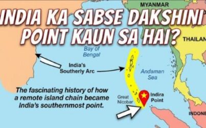
India ka sabse dakshini point kaun sa hai?
If someone asks which is the southernmost part of India, most people may be tempted to say ‘Kanyakumari’. That is because Kanyakumari is a very popular tourist destination and often promoted as the southern tip of India. This also may not be entirely wrong, since Kanyakumari is in fact the southern tip of India. However, when the question is about the southernmost point of India, the answer is something else.
That is why many people get confused between the southern tip of India and the southernmost point of India or ‘India ka sabse dakshini point’. This is more of a technical thing than anything else. However, even then, it is important to understand the difference. So, to answer the original question, the southernmost point of India is not Kanyakumari, but the Indira Point, located in the Andaman and Nicobar Islands.
The Indira Point is specifically located on the Great Nicobar Island in the Nicobar district. This is actually around 1,640 km away from Kanyakumari. The shortest straight distance from Indira Point to mainland India is somewhere around the southeast coast of Tamil Nadu, just north of Chennai. If you follow a straight line, this connection will be around 1,200 km. So, the southernmost point of India is actually quite far from the Indian mainland.
Interesting facts about Indira Point
For an even more accurate analysis, you can look at the geographical coordinates of Indira Point. It is located at approximately 6°46′50″N 93°49′33″E (around 6.78°N latitude). This is the southernmost point of India’s entire territory including islands. Interestingly, Indira Point is much closer to foreign nations than it is to the Indian mainland. For example, Indonesia is just around 145 km from Indira Point.
Similarly, Indira Point is much closer to other countries such as Malaysia, Thailand and Myanmar. Andaman and Nicobar Islands came under Indian rule since these were part of the British colonial framework. The British had established a naval base and a large prison complex. Most of the prisoners and the people who worked on the islands were from India. This made it a natural choice for its transfer to India.
Indira Point was earlier known as Pygmalion Point or Parsons Point. It was renamed Indira Point in the mid-1980s (around 1985) in honor of former Prime Minister Indira Gandhi. One of the key attractions is a 45-meter tall lighthouse, built in 1972. It serves as an important navigational aid. The surrounding areas are rich in biodiversity and include marine life and tropical rainforests. Indira Point is also strategically important for maritime security and navigation in the Indian Ocean.